


Drone Drifter | Planning information checked September 17, 2026
The shot I’d plan for February’s eclipse starts on the ground: a filtered camera recording the ring of sunlight, with the drone handling a separate view of the landscape. That gives each camera a useful job and gives me a workable film if the drone stays in its case.
The February 6, 2027 solar eclipse is annular. The Moon leaves a bright ring around its edge instead of covering the Sun completely. There is no totality window. If you are photographing the Sun, the appropriate solar filter stays on throughout the event. NASA’s annular eclipse guidance
For this guide, I’m concentrating on observing bases in Chile and Argentina, how to check whether a drone flight is possible, and a filming plan you can rehearse before traveling. The locations below are starting points for research; permission to watch an eclipse and permission to fly are separate questions.
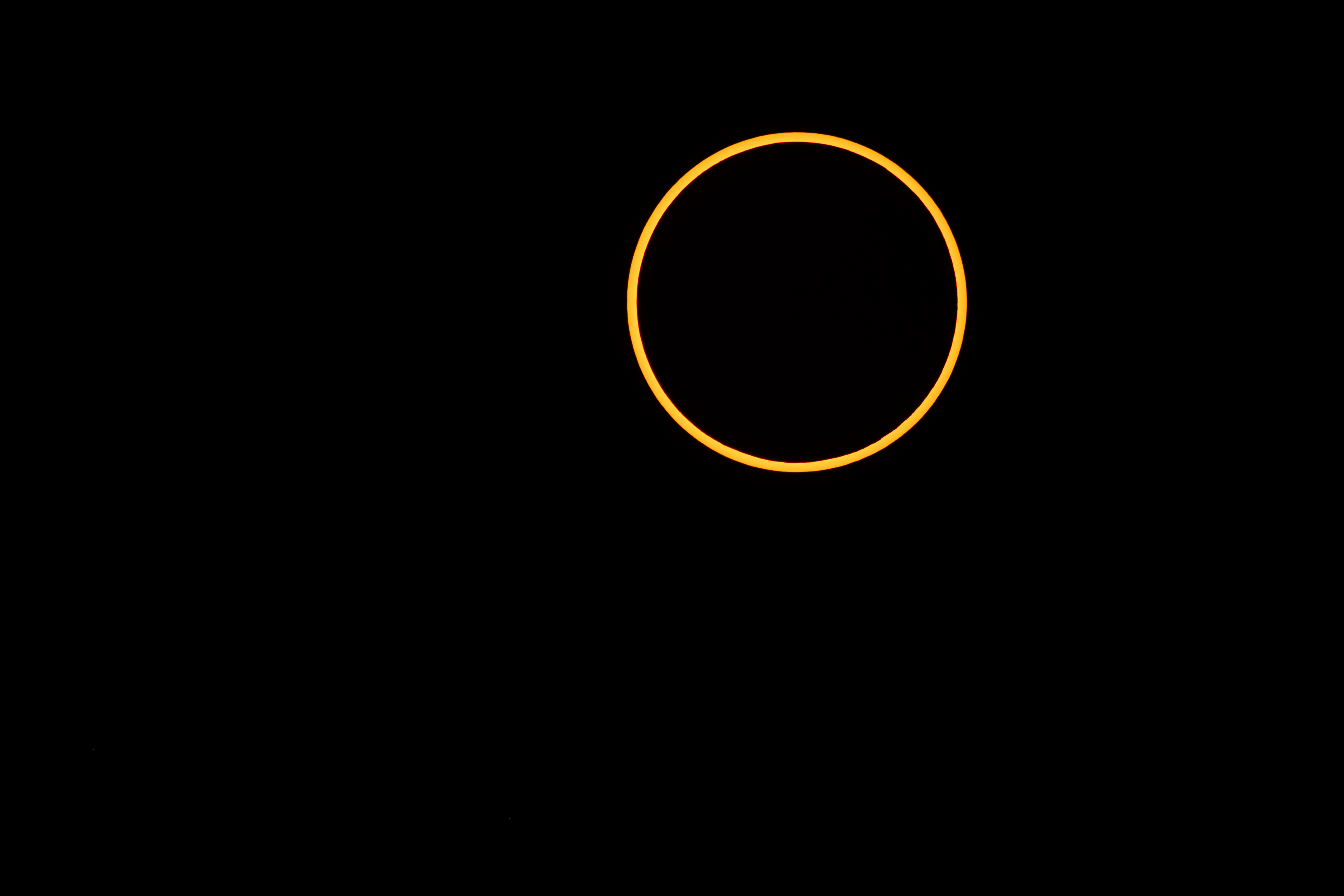
An annular eclipse photographed on October 14, 2023, illustrating the eclipse type expected in February 2027. Photo: NASA/Jim Spann; courtesy NASA’s Goddard Space Flight Center. Image source.
When the February 2027 eclipse happens
The eclipse takes place on Saturday, February 6, 2027. Its duration at greatest eclipse is about 7 minutes 51 seconds, but your own stretch of annularity depends on your location. That number is not a flight schedule. NASA’s 2027 eclipse catalog
Find your exact observing point on an eclipse map. A nearby city can be useful for accommodation while your camera position falls outside the annularity corridor. Check the latitude and longitude, the local time zone, when the partial phase begins, when annularity starts and ends, and when the partial phase finishes.
Use the EclipseWise local circumstances calculator to investigate a position. Keep the source and time zone beside the times you write down. A global eclipse maximum is not necessarily your local maximum.
What I would ask the drone to capture
I’d give the drone a modest shot list: a view that establishes the place, a slow movement that reveals the terrain, and perhaps a repeat of the same composition as the light changes. Keep the Sun outside the planned frame and check the camera manufacturer’s guidance.
A detailed image of the solar ring belongs in a separate ground-camera plan. A wide aerial view and a close-up of the Sun ask different things of the equipment. Trying to get both from one drone can make the shoot more complicated without improving the finished story.
There is a specific equipment reason to be cautious about long solar shots. DJI’s Mini 5 Pro manual warns that pointing its camera at intense light sources such as the Sun for an extended period can damage the sensor. That warning is not an approval for a homemade airborne solar-filter setup. DJI Mini 5 Pro manual, Camera Notice
If the ring is the shot you most want, put your time into the ground camera first. You can still tell the story of the place through footage recorded before or after the peak, provided the edit makes the timing clear.
Subscribe free to Drone Drifter for updates to this eclipse filming guide.
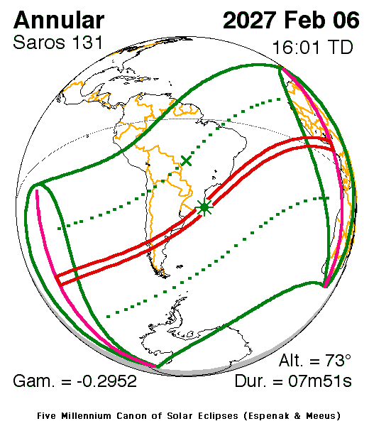
The narrow red corridor marks the February 6, 2027 annular-eclipse track. The printed time uses TD, not local time; duration varies by location. Eclipse Predictions by Fred Espenak and Jean Meeus (NASA’s GSFC). Map source · Map key.
Three observing bases worth researching
Esquel and Trevelin in Argentina
Both towns lie in the annularity corridor described by Grupo Astronómico Osiris. Esquel’s city calculation puts the maximum at about 11:56 a.m. local time, with roughly seven and a half minutes of annularity. Use those rounded figures to understand the day, then calculate the contacts for your actual camera position. Regional eclipse guide, Esquel eclipse circumstances
This would be my first region to investigate for an inland landscape sequence. I’d look for a lawful, accessible location with a clear view and enough room to keep the aircraft away from other observers. A spectacular viewpoint is of little use if the takeoff area, airspace or nearby protected land rules out the flight.
Viedma in Argentina
Viedma provides an eastern alternative. The city’s eclipse calculation identifies an annular eclipse, so it belongs on the observing shortlist. Viedma eclipse calculation
I’d compare access, the intended foreground, nearby airspace and the route to a backup observing point before choosing between eastern and inland bases. Do that comparison around a specific site rather than treating a whole city as a drone location.
Castro and Chiloé in Chile
Castro is also in the annularity corridor. It gives this trip a different setting, but the eclipse path is only the first part of the decision. Castro eclipse calculation
Weather deserves particular attention when comparing Chile with Argentina. Meteorologist Jay Anderson’s eclipse climatology shows cloudiness increasing over the Andes and falling on the Argentine side toward the plains. That supports investigating eastern Patagonia for clearer historical conditions. It does not predict the weather on February 6. Eclipsophile’s February 2027 analysis
I’d keep any backup move practical: somewhere I can reach in time, set up calmly and use legally. A cloud escape route is no help if it leads into airspace or land where the drone cannot operate.
Check the drone rules before building the trip around a flight
Argentina
ANAC’s current framework uses Open, Specific and Certified categories. Its guidance says qualifying Open-category operations do not require a remote-pilot licence or CETA, but calls for a digital sworn declaration containing aircraft and operator details. Restrictions involving airspace, uninvolved people and emergency activity still apply. ANAC’s current framework
For a visiting pilot, confirm the declaration procedure and any other requirements for your aircraft and proposed operation directly with ANAC. Have your nationality, aircraft model, operating weight, purpose, coordinates, date and planned height ready. Do not assume an overseas certificate settles those questions.
National parks are a separate constraint. Argentina’s parks authority says visitors cannot fly drones in its protected areas. Do not make an ordinary recreational flight plan for a national park without establishing a valid authorization route. National parks FAQ
Chile
Chile distinguishes operations over populated areas under DAN 151 from operations over unpopulated areas under DAN 91. The current DGAC index lists DAN 151 Edition 3; a newer consultation draft appearing online is not the same thing as an effective rule. DGAC regulations index, DGAC operating guidance
Under DAN 151, prior authorization involves documentation including aircraft registration, pilot credentials, the applicable insurance documentation, coordinates and site permission. Its definition of a populated area includes open-air gatherings. An eclipse crowd can therefore matter even when the surrounding landscape looks rural. DAN 151 Edition 3
Ask DGAC which route applies to the specific flight before booking around it. CONAF also states that tourist and recreational drone use is prohibited in state protected wild areas. A scenic park should not be treated as an available launch site. CONAF drone guidance
Keep the solar camera and landscape camera plans separate
For direct solar photography, use a suitable solar filter mounted over the front of the ground camera’s optics. Ordinary drone ND filters and eclipse viewing glasses are not substitutes for a camera filter intended for that use. NASA’s annular photography advice
Rehearse the actual camera, lens and filter combination. Set focus, make test exposures and check the recorded files. Write down settings that worked with that equipment. A generic shutter-speed recipe cannot account for every filter, lens and camera.
For the drone landscape sequence, I’d rehearse the composition and the amount of attention the shot needs. Test the chosen exposure mode and white balance, review the files on a larger screen, and decide what you can operate comfortably while maintaining control of the aircraft. The eclipse is a poor moment to discover an unfamiliar camera menu.
A manageable shot sequence
Before eclipse day: confirm the site and flight requirements, rehearse the camera setup, download your planning information, and choose a ground-only alternative. Check how long setup actually takes.
Before the peak: capture any permitted establishing footage that does not need the eclipse at its maximum. A quiet landscape shot and a few ground-level details can do a lot of work in the finished film.
During the partial phase: run the ground-camera sequence at intervals you have rehearsed. If you also fly, make it a deliberate flight with a defined landing time rather than an open-ended hover.
Before annularity: if you are working alone and need to operate the ground camera, land with enough time to put the controller away and settle into that job. Work backward from the local contact times, allowing for the return, landing and an interruption. Do not base the margin on an advertised maximum flight time.
During annularity: keep the solar filter on the camera photographing the Sun. Follow the ground-camera plan and leave yourself a moment to watch through appropriate eclipse viewers.
Afterward: record the departure and a few details of the location. Keep notes about which clips were captured before, during and after the eclipse. If you build a composite image, label it as a composite.
A separate drone pilot and ground-camera operator can divide the work, but the pilot still has to meet the operating requirements. A camera assistant does not make an otherwise unsuitable flight appropriate.
Fill out the plan before packing
Write down the exact location and a backup; local eclipse contacts and their source; aviation and site permissions; aircraft and camera details; the division of filming duties; and a latest landing time. Add the conditions that would make you keep the aircraft grounded.
Save the plan somewhere available offline. Recheck weather and current airspace information close to the event. Keep a useful ground-camera story ready, so a canceled flight does not become a canceled shoot.
Questions worth settling early
Can I photograph the ring with a normal drone ND filter
Do not use a standard ND filter as a substitute for a purpose-made solar filter. Build the solar-disc shot around properly supported camera equipment, and follow the manufacturers’ instructions for the exact setup.
Does the solar filter come off at maximum eclipse
No. February’s eclipse is annular, so there is no totality interval. Keep the appropriate solar filter in place for direct solar photography throughout.
Is a city inside the eclipse path a legal drone location
No. Eclipse visibility describes the sky. Flight permission depends on the aircraft, pilot, airspace, activity and exact site.
Should I bring the drone if I am traveling alone
Bring it if you have a useful, permitted landscape shot and enough time to manage it. If operating it means losing the ground-camera sequence you traveled for, I’d simplify the plan.
The February shoot I would aim to bring home is a short, coherent film: the setting, the changing light, the filtered ring and the people experiencing it from the ground. A few deliberate shots can carry that story.
Subscribe free to Drone Drifter for updates as the February eclipse approaches and for our August 2, 2027 total-eclipse planning coverage.